月の色を測るThe Moon's colors, measured
アルテミスII・クルーが見た月の色を、クルー自身の生データで測るArtemis II · the colors the crew saw, measured in their own raw photographs
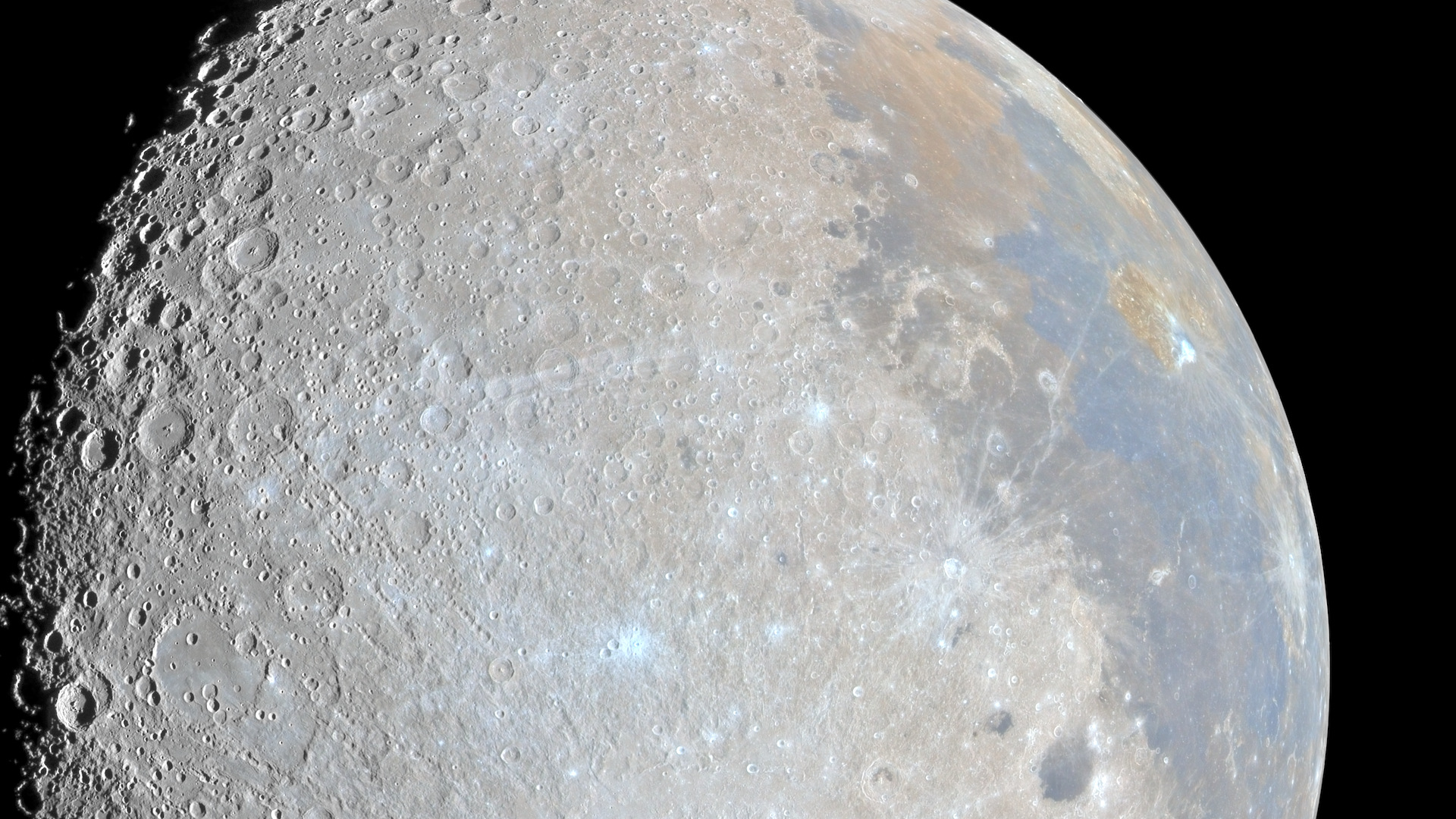
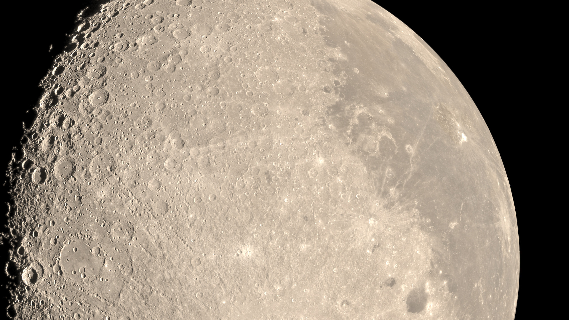
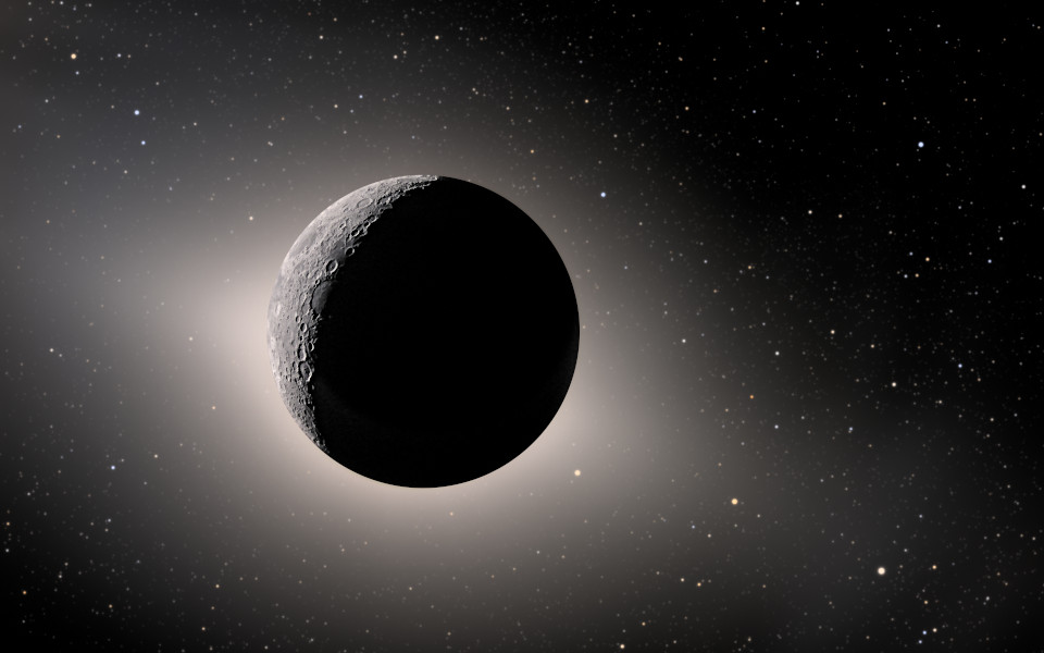
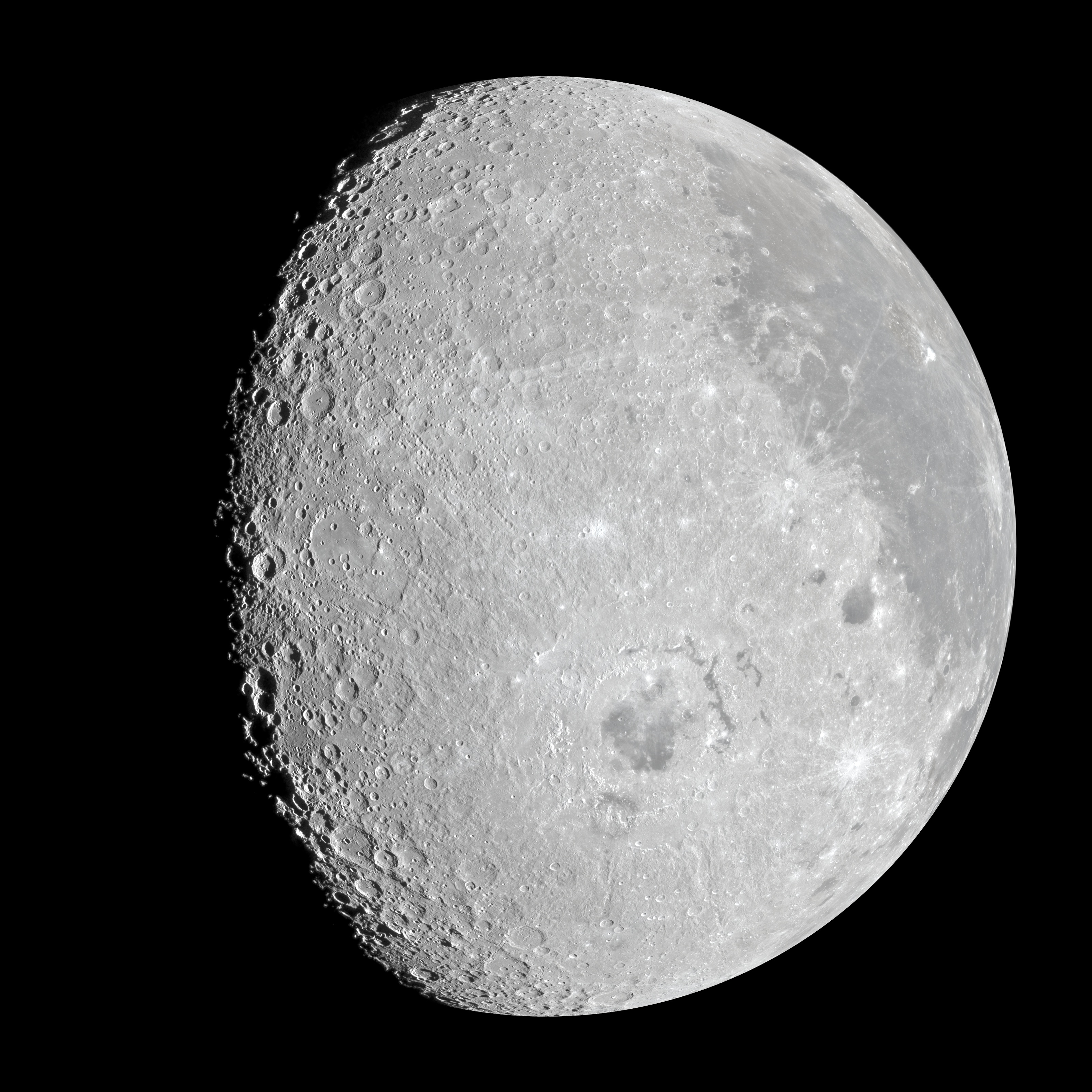
 トゥルーカラー(近似)Approximate true color
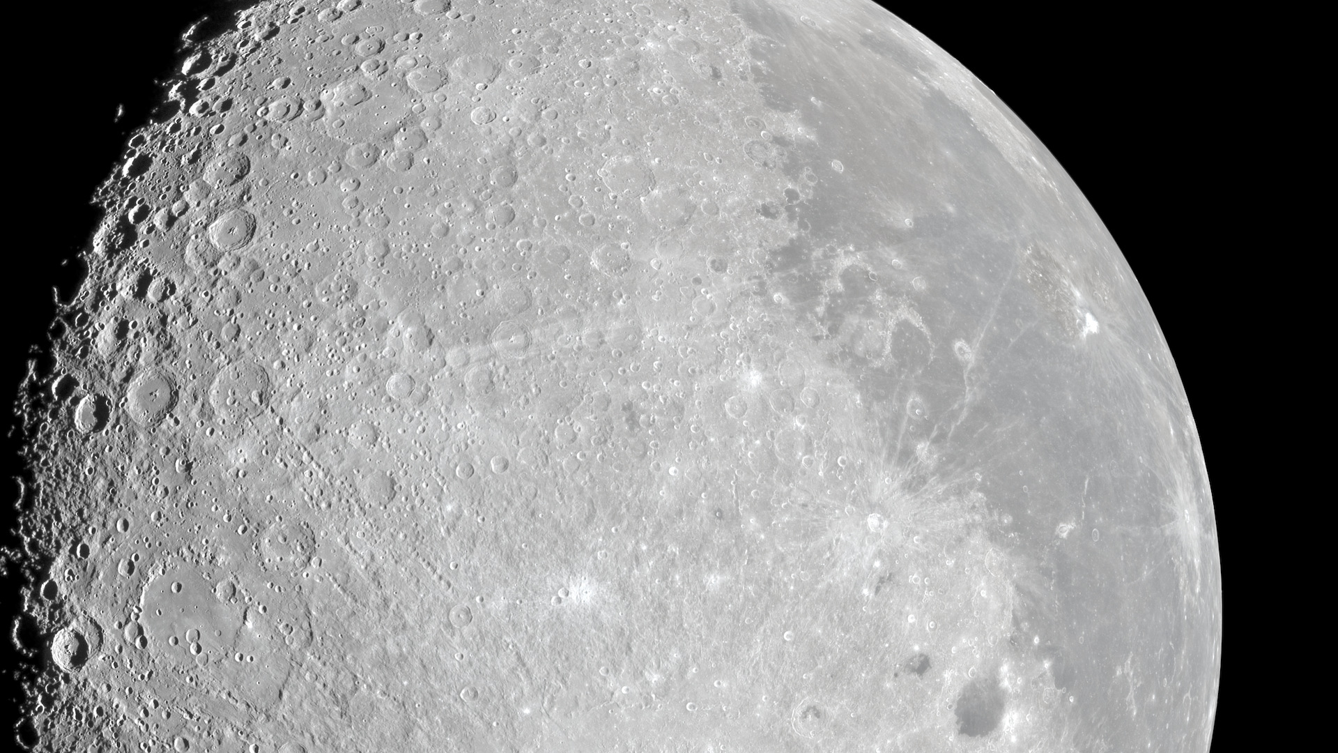
ニュートラル:月の平均を灰色にNeutral balance: the Moon's average set to gray
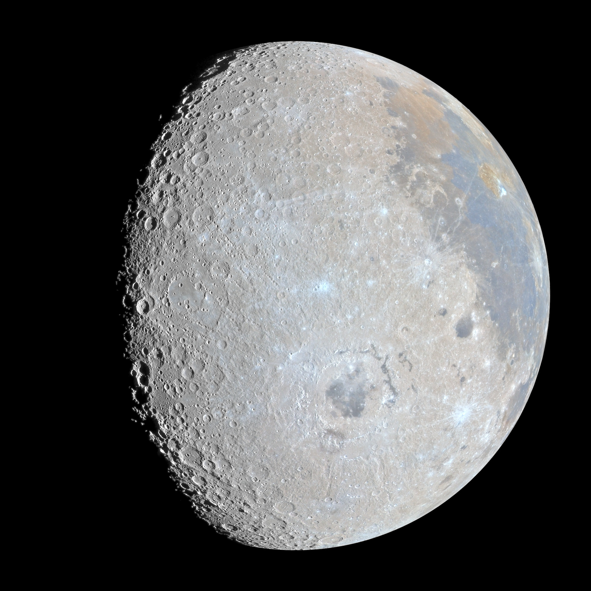
色の差×10Color differences ×10
ドラッグするか、ボタンで切り替えて比べられます。左:トゥルーカラー(近似)。右:同じ写真の色の差を10倍にしたもの。「ニュートラル」は月の平均を灰色に合わせたもので、多くの写真の見え方です。生成や描き足しは一切していません。Drag to compare, or use the buttons. Left: approximate true color. Right: the same picture with its differences in color multiplied by 10. Neutral balance sets the Moon's average to gray, as most photographs show it. Nothing was generated or painted in.
インタラクティブビューアInteractive viewer写真とクルーの報告を見るExplore the picture and the crew's reports3200×3200画素・測った色と軌道からの予測を含む5つの表示・各地点でのクルーの言葉・見どころめぐり3200 × 3200 pixels · five versions, including the color measured and the color predicted from orbit · the crew's words at each place · a tourすぐに見る:Jump to: アリスタルコス台地Aristarchus plateau コックが描いた線The line Koch drew 東の海の外側のリングOrientale's outer rings
画像:NASA/Artemis II Crew/画像処理:Stefano Ivan StingaImages: NASA/Artemis II Crew · Processing: Stefano Ivan Stinga
ダウンロードDownloads
3200 pxの画像はカメラ本来の縮尺で、窓越しの80 mmレンズの解像は約2画素のため、等倍ではやわらかく見えます。くっきり見えるのは2000 pxの版です。16ビットTIFF(3200×3200、26〜30 MB)はこのサイトで配信できる大きさを超えるため、ご連絡いただければお送りします([email protected])。The 3200 px pictures are at the camera's native scale, where the 80 mm lens through the window resolves about two pixels, so they look soft at 100%; the 2000 px versions are the sharp ones. The 16-bit TIFFs (3200 × 3200, 26 to 30 MB) are larger than this site can serve, so they are available on request: [email protected].
2026年4月6日、アルテミスIIのクルーは、写真ではふつう灰色に写る月に、茶色や黄色、さらには緑まで見えると話していました。クルー自身が撮った生データで色を測り、月周回軌道から作られた色の地図と比べました。茶色と黄色は、クルーが言った場所に確かにあります。緑はアリスタルコス台地でのわずかなずれだけで、東の海盆地の「沼のような色」は確認できませんでした。On 6 April 2026 the Artemis II crew described browns, yellows and even greens on a Moon that photographs usually show as gray. I measured the colors in their own raw frames and compared them with color maps made from lunar orbit. The browns and yellows are there, where the crew said they were. The green is only a slight shift at the Aristarchus plateau, and the swamp-like colors at Orientale are not confirmed.
月全体The whole Moon
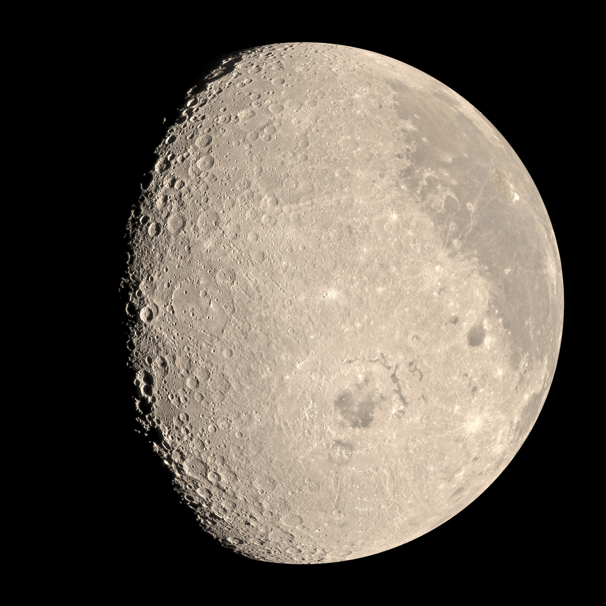
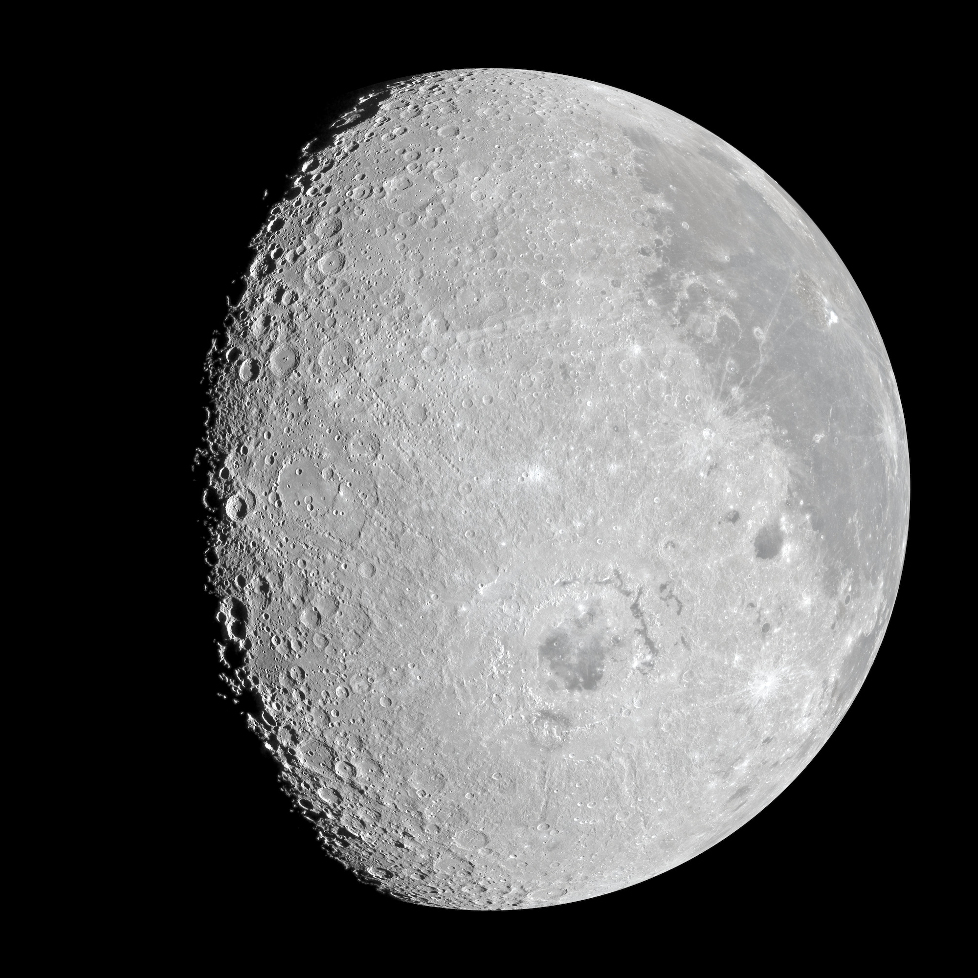 トゥルーカラー(近似)Approximate true color
ニュートラル:月の平均を灰色にNeutral balance: the Moon's average set to gray
色の差×10Color differences ×10
オリオンは月の中心から16,030 km、地球から見た月の西の縁のすぐ外側の上空にいました。円盤の左側が裏側で、右上に嵐の大洋とアリスタルコス台地、中央の下に東の海があります。北が上です。×10の版のような画像は「ミネラルムーン」と呼ばれることがあります。ここに見える色は写真そのものの色で、その差を10倍にしています。鉱物の地図ではありません。Orion was 16,030 km from the Moon's center, above a point just beyond the Moon's western edge as seen from Earth. The far side fills the left of the disk. Oceanus Procellarum and the Aristarchus plateau are at the upper right, Mare Orientale below the center. North is up. Pictures like the ×10 version are often called a "mineral Moon". The colors here are the photograph's own, with their differences multiplied by 10. It is not a map of minerals.
茶色、黄色、少しの緑Brown, yellow, a little green
アルテミスIIのクルーが月に見た色を測るMeasuring the colors the Artemis II crew saw on the Moon
4人の宇宙飛行士が、灰色の月に色を見たと語りました。クルー自身の生データを、飛行の何年も前に月周回軌道から作られた色の地図と比べると、どの色が本当にあったのかがわかります。Four astronauts described color on a gray Moon. Their own raw photographs, compared with color maps made from lunar orbit years before the flight, show which colors were there.
2026年4月6日、オリオンが月の裏側を回り込むあいだ、アルテミスIIのクルーは、写真ではふつう灰色に写る月の色について何度も話していました。リード・ワイズマンはアリスタルコス付近を "a brownish green glass"(茶色がかった緑のガラス)、"very muted"(とても控えめ)と表現しました。ジェレミー・ハンセンはアリスタルコス・クレーターの西に "brownish hues"(茶色がかった色合い)を見ました。ビクター・グローバーは "north toward the north pole"(北極の方へ)、茶色が "browner and browner"(だんだん茶色く)なると話しました。クリスティーナ・コックはアリスタルコス台地を "a jaundiced cheek of the Moon"(黄疸の出た月の頬)と呼び、東の海盆地の遠い外れに "swamp-like colors"(沼のような色)を見つけました。On 6 April 2026, as Orion swung around the far side of the Moon, the Artemis II crew kept reporting color on a Moon that photographs usually show as gray. Reid Wiseman called the Aristarchus region "a brownish green glass", "very muted". Jeremy Hansen saw "brownish hues" west of Aristarchus crater. Victor Glover saw brown "north toward the north pole", getting "browner and browner". Christina Koch called the Aristarchus plateau "a jaundiced cheek of the Moon", and found "swamp-like colors" in the far reaches of the Orientale basin.
10月7日に公開されたNASAの『Preliminary Lunar Science Report(月科学速報)』には、これらの言葉が記録されています。報告書は、色を強調したクルーの写真を1枚示し、クルーが色を見た場所の書き込みを軌道上から作られた鉱物の地図と比べて、火山ガラスの粒が原因ではないかとしています。ただし、どのカメラもこのミッションのために較正されていないため、色の分析は "necessarily qualitative"(必然的に定性的)で、画像は "cannot independently be used to quantify color"(それだけでは色の定量には使えない)とも書いています。ニュースはクルーの言葉を繰り返し伝えました。NASA's Preliminary Lunar Science Report, published on 7 October, records these words. It shows one crew photograph with its colors stretched, compares the crew's annotations of where they saw color with mineral maps made from orbit, and suggests volcanic glass beads as a cause. But it also says that because none of the cameras were calibrated for the mission, its analysis of color is "necessarily qualitative", and that the images "cannot independently be used to quantify color". News stories repeated the quotes.
私の知る限り、クルーが語った色を、クルーの写真の中で場所ごとに実際に測った人はまだいません。生データは公開されていて、較正がないことを補う方法もあるので、測ってみました。To my knowledge, nobody has yet taken the crew's photographs and measured, place by place, the colors they described. The raw frames are public, and there is a way around the missing calibration, so I did.
茶色と黄色は、クルーが言った場所に、写真の中に確かにあります。昔から知られている月の鉱物の色です。緑はアリスタルコス台地でのわずかなずれとして現れるだけです。東の海盆地の沼のような色は確認できませんでした。The browns and yellows are in the frames, where the crew said they were, and they are the Moon's long-known mineral colors. The green shows up only as a slight shift at the Aristarchus plateau. The swamp-like colors at Orientale are not confirmed.
いつ、何を話したかWhat they said, and when
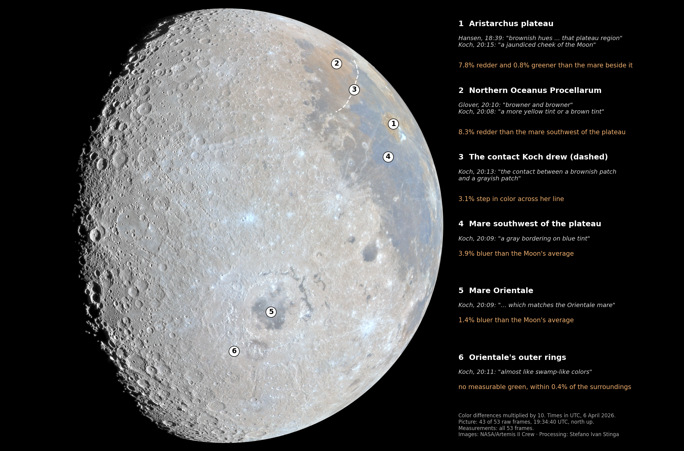
クルーのタブレットが声を録音しており、NASAが時刻つきの書き起こしを公開しています。図1はその一部を月の上に示したもので、ビューアではそれぞれの報告を、クルーの言葉と時刻(4月6日、UTC)つきで見られます。このうちいくつかは、ある色がどこで終わり、別の色がどこから始まるかを述べているので、確かめることができます。The crew's tablets recorded their voices, and NASA has published transcripts with times. Figure 1 places a selection of their reports on the Moon, and the viewer shows each of them with the crew's words and the time (UTC, 6 April). Several of these statements say where one color ends and another begins, so they can be tested.
確かめ方The test
19時34分40秒(UTC)、クルーのニコンD5の1台が80 mmで月全体を5秒間に53枚撮影しました。オリオンは月の中心から16,030 km、地球から見た月の西の縁のすぐ外側(西経106°)の上空にいたため、1枚の中に裏側の東の海盆地と、表側の嵐の大洋とアリスタルコスの両方が入っています。At 19:34:40 UTC one of the crew's Nikon D5 cameras took 53 frames of the whole Moon in five seconds, at 80 mm. Orion was 16,030 km from the Moon's center, above a point just beyond the Moon's western edge as seen from Earth (106° W), so the frame holds both the Orientale basin on the far side and Oceanus Procellarum and Aristarchus on the near side.
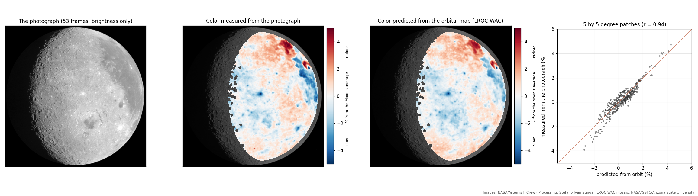
53枚の生データは、カラー画像に変換せずにそのまま平均しました。こうすると、各画素の赤・緑・青の値はセンサーそのものの値になります。そのうえで、月面のあらゆる場所で2つの量を測りました。地面がどれだけ赤いか(赤の信号を青で割ったもの)と、どれだけ緑か(緑を赤と青の平均で割ったもの)で、どちらも月全体の平均に対する値です。I averaged the 53 raw frames without converting them to a color picture first, so that each pixel's red, green and blue values are the sensor's own. Then I measured two things everywhere on the disk: how red the ground is (red signal over blue) and how green (green over the mean of red and blue), both relative to the Moon's average.
NASAの報告書が言うとおり、宇宙船の窓越しのカメラは較正された観測装置ではありません。そこで、比較によって確かめました。NASAの月周回衛星ルナー・リコネサンス・オービター(LRO)は2009年から月を回っており、その広角カメラのチームが2017年に、照明の条件を補正した7色のモザイク地図を公開しています。JPLのHorizonsシステムによるオリオンの位置を使って、この地図を19時34分40秒にオリオンから見えたとおりの向きに投影し、写真と1画素ずつ比べました。A camera behind a spacecraft window is not a calibrated instrument, as NASA's report says. So the test is a comparison. NASA's Lunar Reconnaissance Orbiter has been in lunar orbit since 2009, and its wide-angle camera team published a seven-color mosaic, corrected for lighting, in 2017. I projected that map into the exact view Orion had at 19:34:40, using Orion's position from JPL's Horizons system, and compared the two pixel by pixel.
結果1:茶色は月そのものの色Result 1: the browns are the Moon's own
2つの地図は一致します。陽の当たる月面全体で、カメラの赤と青の比の色は、相関0.93で軌道の地図に沿っています。35分後に別の構図で撮られたもう1組の写真も、相関0.99で同じ地図を再現します。400 mmで手持ちで撮られた1枚の写真でさえ、3 kmの細かさまで軌道の地図と同じまだら模様を示します(相関0.9)。The two maps match. Across the sunlit disk, the camera's red-to-blue color follows the orbital map with a correlation of 0.93. A second set of frames taken 35 minutes later, framed differently, repeats the camera's map with a correlation of 0.99. Even single handheld frames at 400 mm show the same patchwork as the orbital map down to 3 km (correlation 0.9).
| クルーの言葉What the crew said | カメラが示すものWhat the camera shows | 軌道の地図の予測What the orbital map predicts |
|---|---|---|
| アリスタルコス台地の茶色(ハンセン、ワイズマン、グローバー)Brown at the Aristarchus plateau (Hansen, Wiseman, Glover) | 台地はその南西の海より7.8%赤いThe plateau is 7.8% redder than the mare southwest of it | 6〜6.5%6 to 6.5% |
| 北極の方へ茶色(グローバー)、北の海は黄色か茶色(コック)Brown north toward the pole (Glover); northern mare yellow or brown (Koch) | 嵐の大洋の北部は、台地の南西の海より8.3%赤いNorthern Procellarum is 8.3% redder than the mare southwest of the plateau | 6.5〜7%6.5 to 7% |
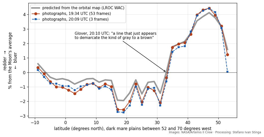
| 灰色と茶色の間の「線」(グローバー、コック)"A line" between gray and brown (Glover, Koch) | 北緯33°付近で、海の色が約120 kmの間に約4%変わり、その北でも赤みが増し続けるMare color steps by about 4% within about 120 km near 33° N, then keeps reddening northward | 同じ場所に同じ段差the same step, at the same place |
| 南の海は東の海と同じ「青に近い灰色」(コック)Lower maria "gray bordering on blue", like Mare Orientale (Koch) | 台地の南西の海は-3.9%、東の海は-1.4%で、どちらも月の平均より青いMare southwest of the plateau -3.9%, Mare Orientale -1.4%, both bluer than the Moon's average | -2.9%と-1.5%-2.9% and -1.5% |
2組の写真は、0.1%以内で同じ数値を示します。Both sets of frames give the same numbers to within 0.1%.
色そのものは、月の科学にとって新しいものではありません。アリスタルコス台地は非常に大きな火山ガラスの堆積物に覆われていて、1910年にR. W. ウッドが紫外線で月を撮影して以来、色の変わった場所として知られてきました。海の中の、より赤い溶岩と青い溶岩の色の境界は半世紀前に望遠鏡写真から地図にされ、青い溶岩はチタンが多いとすでに読み解かれていました。NASAの報告書も、言葉と地図で同じ結びつきを示しています。写真が加えるのは測定です。4人は16,000 kmの距離から自分の目でこれらの色を見て、声に出して説明していました。境界がどこを通るか、色がおおよそどれくらい強いかについて、その説明は正しかったのです。The colors themselves are not new to lunar science. The Aristarchus plateau is covered by a very large deposit of volcanic glass, and has been known as an odd-colored patch since R. W. Wood photographed the Moon in ultraviolet light in 1910. Color boundaries between redder and bluer lavas in the maria were mapped from telescope photographs half a century ago, and the bluer lavas were already read then as richer in titanium. NASA's report makes the same connection in words and maps. The frames add the measurement. Four people saw these colors with their own eyes from 16,000 km and described them out loud, and they were right about where the lines run and roughly how strong the colors are.
コックが描いた線The line Koch drew
この中でひとつだけ、ほかよりも詳しく確かめられるものがあります。コックが描いたからです。20時13分、コックは "This is the photo of the contact between a brownish patch and a grayish patch."(これは茶色っぽい部分と灰色っぽい部分の境目の写真)と言い、タブレットに表示した月のシミュレーション画像の上に、その境目を短い赤い線で1本描きました。線の片側には "brown"(茶色)、反対側には "grey (almost blue)"(灰色、ほとんど青)と書いています。One of these statements can be checked more closely than the rest, because Koch drew it. At 20:13 she said: "This is the photo of the contact between a brownish patch and a grayish patch." She then marked the contact on her tablet, on a simulated view of the Moon, with one short red line. On one side she wrote "brown", on the other "grey (almost blue)".
その線を月面の座標に移しました。線は北緯約30°・西経73°から北緯約49°・西経47°まで、嵐の大洋の北部を斜めに横切っています。色を強調した写真に重ねると、線は茶色い海の下の縁に沿い、反対側は青みがかった海です。東側の3分の2でいちばんよく合います。西の端では境界から1°ほどずれますが、コックの絵は小さく(月の半径が約150画素)、1〜2°より正確には置けません。I transferred her line to lunar coordinates. It runs from about 30° N, 73° W to about 49° N, 47° W, diagonally across northern Oceanus Procellarum. Laid over the photograph with its colors exaggerated, it runs along the lower edge of the brown mare, with the bluish mare on its other side. The fit is closest along its eastern two thirds. Toward its western end it sits a degree or so off the boundary, and her small drawing (about 150 pixels for the Moon's radius) can't be placed better than one or two degrees.
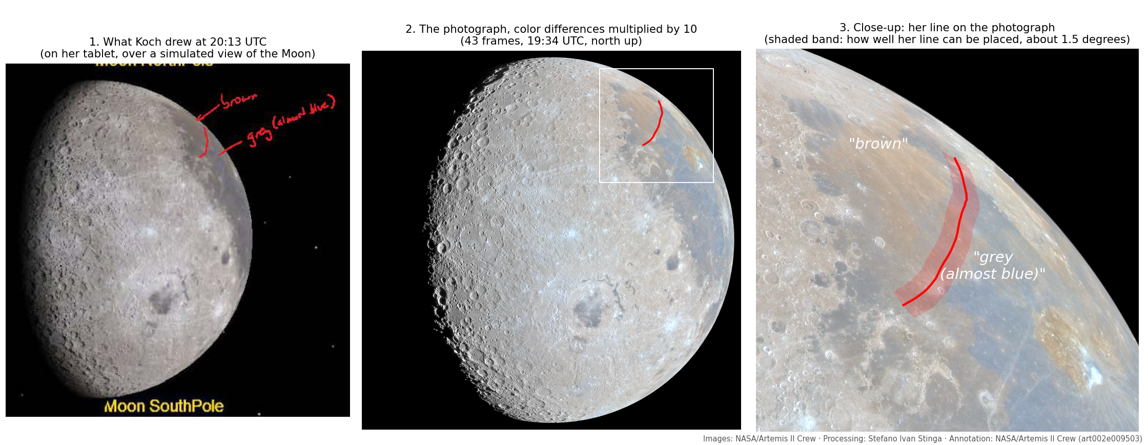
線から150 km以内の海は、コックが "brown" と書いた側では月の平均より2.3%赤く、"grey (almost blue)" と書いた側では0.9%青くなっています。カメラの赤と青の比の色で約3%の段差で、2組の写真のどちらでも同じです(3.1%と3.0%)。軌道の地図の予測は2.1〜2.5%です。上の表の約4%は測り方が違い、海を南から北へたどったときの変化です。The mare within 150 km of her line is 2.3% redder than the Moon's average on the side she labeled "brown" and 0.9% bluer on the side she labeled "grey (almost blue)". That is a step of about 3% in the camera's red-to-blue color, in both sets of frames (3.1% and 3.0%). The orbital map predicts 2.1 to 2.5%. The 4% in the table above is measured differently, along a south-to-north profile of the mare.
結果2:緑は黄色の方へのわずかなずれで、台地だけResult 2: the green is a slight shift toward yellow, at the plateau only
クルーは "green"(緑)という言葉をよく使いましたが、たいていは茶色と組み合わせていました。"brownish green"(茶色がかった緑)、"greenish-brown"(緑がかった茶色)、"tannish green"(黄褐色がかった緑)などです。写真の中では、アリスタルコス台地は隣の海より0.6〜0.8%緑が強く(2組の写真のどちらでも)、北の茶色い海と比べても0.6%緑が強く、赤みはわずかに少なくなっています。茶色より少し赤みが少なく、少し緑が強い色は、より黄色く見えます。これはコックの "more yellow than the other brown"(ほかの茶色より黄色い)という描写にいちばんよく合います。The crew used "green" often, usually joined to brown: "brownish green", "greenish-brown", "tannish green". In the frames, the Aristarchus plateau is 0.6 to 0.8% greener than the mare beside it, in both sets of frames, and 0.6% greener than the brown mare to the north while being slightly less red. A patch that is a little less red and a little more green than a brown one is yellower. That fits Koch's description best: "more yellow than the other brown".
台地の外では、緑は確認できません。ほかの場所のカメラの緑の信号は、月をどう構図に入れたかで変わるので、レンズか窓から来ていると考えられます。また、軌道上のカメラには、それを確かめられる波長のフィルターがありません。Beyond the plateau I can't confirm any green. The camera's green signal elsewhere changes with how the Moon was framed, which means it comes from the lens or the window, and the orbital camera has no filter at the right wavelength to check it against.
結果3:沼のような色は確認できないResult 3: the swamp-like colors are not confirmed
コックが沼のような、苔のような色を語ったのは20時11分16秒、400 mmで東の海盆地の裏側の斜面を撮影していたときです。その10分後、コックはその緑の色合いを、東の海の外側のリングの荒れた地面と "the valleys of all of the rings"(すべてのリングの谷)に位置づけました。20時11分13秒と20時11分23秒のコック自身の写真にはその地面が写っており、月全体の写真はすべてのリングを含んでいます。そこに見える色の構造は本物で、軌道の地図とも一致します。東の海の噴出物は、その外側の古い地面よりわずかに青いのです。しかし、リングの帯どうしの差は1%に満たず(コンマ数%)、画面全体でも最大で約3%であり、測れるような緑の成分は見つかりませんでした。Koch described her swamp-like, mossy colors at 20:11:16 while photographing the far-side flank of Orientale at 400 mm. Ten minutes later she placed the green tones in the rough ground at Orientale's outer ring and "the valleys of all of the rings". Her own frames from 20:11:13 and 20:11:23 show that ground, and the whole-Moon frames cover every ring. The color structure in them is real and matches the orbital map: Orientale's ejecta is slightly bluer than the older ground beyond it. But the differences are a few tenths of a percent between ring zones, about 3% at most across the frame, with no green component I can measure.
これは、コックが何を知覚したかについては何も言っていません。明るい灰色の面に慣れた目が、低い太陽に照らされた荒れた地面を見るとき、その働きはカメラとは違います。測定が示すのは、茶色とは違って、この色を写真からも軌道のデータからも検出できなかったということだけです。This says nothing about what she perceived. An eye adapted to a bright gray surface, looking at rough ground under a low Sun, does not work like a camera. The measurement shows only that, unlike the browns, I could not detect this color in the photographs or in the orbital data.
目に見える差だったのかCould an eye see it?
軌道のデータから、これらの場所を並べたときにどれだけ違って見えるかを、色彩の研究で使われる単位で見積もりました(差1が目に見分けられる最小に近く、2〜3は小さいがはっきりわかる差です)。台地と隣の海の差は2.6、北の茶色い海と青い海の差も2.6になります。東の海のまわりの帯どうしは0.2〜0.5です。つまり茶色は、見えるけれど控えめだったはずです。ワイズマンの言葉どおり "very muted"(とても控えめ)です。From the orbital data I estimated how different these patches would look side by side, in the units color scientists use (a difference of 1 is about the smallest an eye can detect; 2 to 3 is small but clear). The plateau against its neighboring mare comes out at 2.6, and so does the northern brown mare against the bluer mare. The zones around Orientale come out at 0.2 to 0.5. So the browns should have been visible but subtle, which is how Wiseman put it: "very muted".
解説
作り方
- 写真:ニコンD5、80〜400 mmレンズを80 mmで使用、1/1000秒、f/8、ISO 400。53枚(art002e009631〜009683)、カメラの時計で19:34:40〜19:34:45(UTC)。確認用:180 mmの17枚(19:34:53)、85 mmの3枚(20:09:47)、400 mmの1枚ずつの写真(20:10:47〜20:11:23)
- 処理:センサーの生の値から黒レベルを引き、4つのカラーフィルターの面を半分の解像度に平均、写真を位置合わせして平均し、レンズの色にじみを除くため赤と青を緑に合わせています(残りは1/5画素未満)。色の変換、ノイズ低減、生成は一切していません
- 画像:53枚のうち43枚(最もぼやけた10枚を除く)をフル解像度で合成。生データの各サンプルはそれぞれの位置に置くので、色を周囲の画素から補間していません。月の縁で測ったぼけ(0.9画素)をデコンボリューションで一部取り除き、北を上にし、明暗境界線近くの地面と明るい縁が一緒に見えるよう明るさを局所的に圧縮しています。トゥルーカラー(近似):画像の平均を軌道から測った月の色に合わせ、各画素をカメラの公開されている色の応答で変換。ニュートラル:月の平均が灰色になるよう赤・緑・青を調整。×10:色の差を10倍
- 幾何:オリオンの位置、太陽の方向、月の向きはJPL Horizonsによる。カメラの向きと焦点距離は、月の陽の当たる縁と軌道の地図に合わせて求め、両者は約1画素(2.5 km)で一致
- 比較の基準:LROC WACの測光補正済みモザイク、415、566、604、643、689 nm(Sato et al. 2017)
- 色の指標:100 × ln(R/B) と 100 × ln(G/√(R·B))。月面の中央値に対する値で、10 kmに平滑化
- コックの線:書き込み art002e009503 は、20:39:00(UTC)のシミュレーション画像の上に描かれています。その画像を、その時刻のオリオンの位置で合わせ(月の縁、東の海、グリマルディ。北は1°以内で上)、赤い線を月面に投影しました
- クルーの言葉:クルーのタブレットで録音された音声のNASAによる書き起こし(自動音声認識。時刻の精度は1〜2秒)。引用は、繰り返しの語を少し整理しています。英語の言葉はそのまま載せ、日本語は参考訳です
ほかの原因ではないこと
- 地球照:地球で反射した光は太陽の光より青く、クルーは数時間後の日食のあいだ、地球照だけで照らされた月を実際に見ています。しかし19時34分には、地球は月の空で細い三日月で、表側に届く光は太陽の光の約100万分の8でした。陽の当たる地面の色を変えることはできません
- カメラ:どの写真にも、画面を横切るなめらかな色のずれがあり、月の端から端までで赤と青の比が約2%変わります。構図が変わるとずれの向きも変わるので、レンズか窓によるものです。これは取り除きました。隣り合う場所どうしの差は、このずれに左右されません
注意点
- パーセントの値は、オリオンの窓を通したカメラ自身の赤・緑・青によるもので、較正された色ではありません
- 先行研究の調査は、ニュース、論文、プレプリントのウェブ検索によるもので、すべてを見つけられるわけではありません
- 緑についての結果は、ひとつの小さな領域だけに基づいています
- 生成や描き足しは一切していません
About this image
How it was done
- Frames: Nikon D5, 80–400 mm lens at 80 mm, 1/1000 s, f/8, ISO 400; 53 frames, art002e009631 to 009683, 19:34:40–19:34:45 UTC by the camera's clock. Cross-checks: 17 frames at 180 mm (19:34:53), three frames at 85 mm (20:09:47), single frames at 400 mm (20:10:47–20:11:23).
- Processing: raw sensor values, black level subtracted, the four color-filter planes averaged to half resolution, frames aligned and averaged, red and blue registered to green to remove the lens's color fringing (under a fifth of a pixel remains). No color conversion, no noise reduction, nothing generated.
- The picture: 43 of the 53 frames (the 10 softest are left out), combined at full resolution. Every raw sample goes to its own place, so no color is interpolated from its neighbors. The blur measured on the Moon's edge (0.9 pixel) is partly removed by deconvolution, north is turned up, and brightness is compressed locally so that the ground near the terminator and the bright limb show together. Approximate true color: the picture's average is set to the Moon's color as measured from orbit, and each pixel is converted with the camera's published color response. Neutral balance: red, green and blue balanced so the Moon's average is gray. ×10: the differences in color multiplied by 10.
- Geometry: Orion's position, the Sun's direction and the Moon's orientation from JPL Horizons. Camera pointing and focal length fitted to the Moon's sunlit edge and to the orbital map; the two agree to about one pixel (2.5 km).
- Reference: LROC WAC photometrically normalized mosaic, 415, 566, 604, 643 and 689 nm (Sato et al. 2017).
- Color indices: 100 × ln(R/B) and 100 × ln(G/√(R·B)), relative to the disk median, smoothed to 10 km.
- Koch's line: her annotation art002e009503 is drawn on a simulated view for 20:39:00 UTC. I fitted that view (the Moon's edge, Mare Orientale and Grimaldi; north up to within 1°) with Orion's position at that time and projected the red line onto the Moon.
- Crew words: NASA's transcripts of the audio recorded on the crew's tablets (automatic speech recognition; times good to a second or two). Quotes are lightly cleaned of repeated words.
What it wasn't
- Earth-light. Light reflected from Earth is bluer than sunlight, and the crew did see the Moon by Earth-light alone during the eclipse a few hours later. But at 19:34 Earth was a crescent in the Moon's sky and gave the near side about eight millionths of the light the Sun did. It could not tint sunlit ground.
- The camera. There is a smooth color drift across each frame, about 2% in red-to-blue from one side of the Moon to the other. It changes direction when the framing changes, so it is the lens or the window. I removed it; differences between neighboring regions don't depend on it.
Caveats
- The percentages are in the camera's own red, green and blue, through Orion's window. They are not calibrated colors.
- The search for earlier work was a web search of news, papers and preprints. It can't see everything.
- The green result rests on one small region.
- Nothing was generated or painted in.
データNumbers
- コマFrames
- 生データ53枚(art002e009631〜009683)。画像はそのうちシャープな43枚art002e009631–009683: 53 raw frames; the picture uses the sharpest 43
- 時刻Time
- 2026年4月6日 19:34:40(UTC、カメラの時計)6 April 2026, 19:34:40 UTC (camera clock)
- 距離Distance
- 月の中心から16,030 km16,030 km from the Moon's center
- オリオンの真下Below Orion
- 西経106.0°、北緯1.7°106.0° W, 1.7° N
- カメラCamera
- ニコンD5・80 mm・1/1000秒・f/8・ISO 400Nikon D5 · 80 mm · 1/1000 s · f/8 · ISO 400
- 大きさSize
- 3200×3200画素。月の直径は2,755画素、北が上3200 × 3200 pixels; the Moon is 2,755 pixels across, north up
- 軌道の地図Orbital map
- LROC WAC、415〜689 nmLROC WAC, 415–689 nm
- カメラと軌道の地図Camera vs. orbit
- 相関0.93(1画素ごと)、0.94(5°の区画ごと)correlation 0.93 pixel by pixel, 0.94 over 5-degree patches
利用についてUse
報道・記事でのご利用は、上記のクレジットを表記いただければご自由にどうぞ。それ以外のご利用は CC BY 4.0 の条件に従ってください。×10の版を使う場合は、色が強調されていることがわかるよう、「色の差×10」などの説明を添えてください。このライセンスは画像処理(画像、図、ビューア)に対するもので、NASAの画像自体は、米国では一般に著作権の対象になりません。図4のコックの書き込みはNASAの素材です。News and editorial use is welcome with the credit above. Other uses: CC BY 4.0. Please keep "color differences ×10" (or similar) next to any ×10 version, so readers know the colors are exaggerated. The license covers the processing: the pictures, the figures and the viewer. NASA's own images are generally not copyrighted in the United States; Koch's annotation in Figure 4 is NASA material.
連絡先Contact: [email protected] · X: @Sting1_JP · Bluesky: @stinga.jp · Flickr: photostream
クレジットと出典Credits and sources
- 画像:NASA/Artemis II Crew。画像処理:Stefano Ivan StingaImages: NASA/Artemis II Crew. Processing: Stefano Ivan Stinga.
- 生データ:Artemis II Lunar Science Team (2026), Artemis II Crew Camera Data Bundle, NASA PDS Cartography and Imaging Sciences Node, doi:10.17189/x52v-tb80。コマ art002e009631〜009683(80 mm)と art002e019938〜019940(85 mm)Raw frames: Artemis II Lunar Science Team (2026), Artemis II Crew Camera Data Bundle, NASA PDS Cartography and Imaging Sciences Node, doi:10.17189/x52v-tb80. Frames art002e009631 to 009683 (80 mm) and art002e019938 to 019940 (85 mm).
- クルーの音声の書き起こしと書き込み art002e009503:Artemis II Mission Audio bundle, NASA PDSCrew audio transcripts and annotation art002e009503: Artemis II Mission Audio bundle, NASA PDS.
- 軌道からの色:LROC WAC Hapke-normalized mosaic, NASA/GSFC/Arizona State University; Sato, H., et al. (2017), Icarus 296, 216–238, doi:10.1016/j.icarus.2017.06.013Orbital color: LROC WAC Hapke-normalized mosaic, NASA/GSFC/Arizona State University; Sato, H., et al. (2017), Icarus 296, 216–238, doi:10.1016/j.icarus.2017.06.013.
- 暦:JPL HorizonsEphemerides: JPL Horizons.
- NASA (2026), Artemis II Preliminary Lunar Science Report, 7 October 2026. science.nasa.govNASA (2026), Artemis II Preliminary Lunar Science Report, 7 October 2026. science.nasa.gov
- Wood, R. W. (1910), The Moon in Ultra-violet Light: Spectro-selenography. Monthly Notices of the Royal Astronomical Society 70, 226–228. doi:10.1093/mnras/70.3.226Wood, R. W. (1910), The Moon in Ultra-violet Light: Spectro-selenography. Monthly Notices of the Royal Astronomical Society 70, 226–228. doi:10.1093/mnras/70.3.226
- Gaddis, L. R., et al. (2003), Compositional analyses of lunar pyroclastic deposits. Icarus 161, 262–280. doi:10.1016/S0019-1035(02)00036-2Gaddis, L. R., et al. (2003), Compositional analyses of lunar pyroclastic deposits. Icarus 161, 262–280. doi:10.1016/S0019-1035(02)00036-2
- Whitaker, E. A. (1972), Lunar color boundaries and their relationship to topographic features: a preliminary survey. The Moon 4, 348–355.Whitaker, E. A. (1972), Lunar color boundaries and their relationship to topographic features: a preliminary survey. The Moon 4, 348–355.
- ビューア:OpenSeadragon(BSD-3-Clause)Viewer: OpenSeadragon (BSD-3-Clause).
関連する作品Related work
NASAの月科学速報は、色を強調したクルーの写真を示し、クルーの書き込みを軌道からの鉱物の地図と比べています。アンドリュー・マッカーシーさんとリード・ワイズマンさんは、スタックして色を強調した月の裏側を、ダミアン・ピーチさんは色を強調したクルーの写真を公開しています。アマチュア天文家の掲示板Cloudy Nightsでは、生データが公開される前の2026年4月と5月に、NASAのJPEGのホワイトバランスや全体の色が議論されていました。NASA's Preliminary Lunar Science Report shows a color-stretched crew image and compares the crew's annotations with mineral maps from orbit. Andrew McCarthy and Reid Wiseman published a stacked, color-enhanced far side, and Damian Peach published color-enhanced crew images. Amateur astronomers on Cloudy Nights discussed the white balance and overall color of NASA's JPEGs in April and May 2026, before the raw frames were public.